

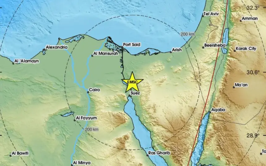
Residents of Cairo, the Suez Canal cities, the Nile Delta and other parts of Egypt were jolted awake early on Monday by an earthquake that lasted only seconds but prompted many people to rush into streets and onto balconies. Tremors were also felt in Gaza, Jordan, Lebanon, and parts of Israel.
Egypt’s National Research Institute of Astronomy and Geophysics (NRIAG) measured the earthquake at magnitude 5.6, locating its epicentre about 38 kilometres north of Suez at a depth of approximately 10 kilometres.
No deaths or widespread damage were reported. Egypt’s Ministry of Health and Population said one person sustained minor injuries, received treatment and was later discharged. Authorities also reported the collapse of a balcony in Suez and partial damage to an old residential building in Cairo’s Rod El-Farag district, where three families were evacuated as a precaution.
International seismic monitoring centres issued slightly lower magnitude estimates, ranging from 5.0 to 5.4. Such variations are common, as agencies rely on different seismic networks, datasets and calculation methods.
In the hours following the main shock, NRIAG recorded between five and six aftershocks, all below magnitude 3, according to the institute’s president, Bassem Nabawy. The total later rose to around 15 aftershocks, most measuring below magnitude 2 and too weak to be felt.
Nabawy described the aftershocks as a natural “stress-release” process as the Earth’s crust adjusts following the main rupture. However, he noted that aftershocks do not completely release the accumulated energy along a fault or eliminate the possibility of further seismic activity. Their frequency typically declines over time, although minor tremors may continue for several days.
The earthquake did not originate along a newly formed fault. The Gulf of Suez is the northern arm of a vast geological rift system that developed when the Red Sea began opening between 20 million and 30 million years ago as the Arabian Plate gradually separated from the African Plate.
“The Gulf of Suez represents one of the northern arms of a giant geological system formed during the opening of the Red Sea, and the faults associated with it remain active today,” said Sherif Elhady, head of NRIAG’s Earthquake Department.
A peer-reviewed study published in the Journal of Seismology in 2025, co-authored by Elhady, describes the Gulf of Suez as a rift extending roughly 350 kilometres. The study attributes present-day earthquakes primarily to continued crustal extension and the reactivation of pre-existing faults.
The Gulf of Suez has experienced several moderate earthquakes in recent decades. A magnitude 5.1 earthquake struck the region in June 2013, followed by another moderate event on 27 December 2022. The two epicentres were about 53 kilometres apart, while the 2022 earthquake generated around 50 aftershocks over five days, ranging from magnitude 1 to 4.4.
The latest earthquake occurred farther north, near the Bitter Lakes, within the northern extension of the Gulf of Suez fault system. However, experts caution that the occurrence of several moderate earthquakes does not indicate that such events follow a predictable cycle.
A seismic catalogue covering the Gulf of Suez between 1900 and 2022 recorded more than 10,000 earthquakes, the vast majority ranging between magnitudes 1 and 4 and concentrated within the upper 20 kilometres of the Earth’s crust. Researchers note that the apparent increase in recorded seismic activity in recent decades is largely attributable to improvements in monitoring technology rather than a significant rise in earthquake frequency.
The relatively shallow depth of Monday’s earthquake explains why it was felt across a wide geographical area. Seismic waves generated by shallow earthquakes lose less energy before reaching the surface, allowing the shaking to travel farther. Nevertheless, experts note that the intensity experienced at any location also depends on factors such as local geology, distance from the epicentre, the direction of fault rupture and the quality of buildings.
Egypt’s devastating 1992 Cairo earthquake illustrates this point. Although it measured only about magnitude 5.8 and occurred near Dahshur at a depth of around 20 kilometres, its proximity to densely populated areas and the vulnerability of many buildings resulted in far greater damage and loss of life.
Despite Monday’s tremor, experts stress that Egypt has not entered a new phase of heightened seismic activity. Most of the country lies within the relatively stable African Plate, with earthquake activity largely concentrated around the Gulfs of Suez and Aqaba, the Red Sea, the eastern Mediterranean, Dahshur and a limited number of local fault systems.
Across the wider Middle East, the highest seismic hazard remains concentrated along the North and East Anatolian fault systems in Türkiye, the Zagros Mountains of western Iran and northern Iraq, the Alborz Mountains in northern Iran, the Makran subduction zone, the Caucasus, the Dead Sea Transform fault, and the Cyprus and Hellenic arcs.
For Egypt, Nabawy said reducing earthquake risk depends not only on seismic monitoring but also on maintaining older buildings. He stressed the importance of regular structural inspections, including checking for water and sewage leaks that can gradually weaken construction materials or undermine the soil supporting building foundations.